-
Europe: Bundle continents and oceans

In this brief volume, the different continents and overflow set. They are also colored on an outline map.
Translated by
 Downloadable resource (86)Teacher, Learning mentor
 -
US National Parks: Webquest

This learning may perceive you as a virtual excursion to three US National Parks via Google Maps (and Street View).
Using waypoints and selected questions the students learn more about the origin and the view of the national parks. Attention is …
Translated by
Downloadable resource (11)Teacher -
Natural disasters: Animations

On this page of the BBC website you can find animations about the following natural disasters: hurricanes, tornadoes, earthquakes, volcanoes and tsunamis.
Step by step explanation of how these phenomena occur, with very clear animations. There …
Translated by
Website (14)Teacher -
Chinese Language and Culture

Kindergarten education
With photos and videos we look through the eyes of a toddler together: what do the children do in a Chinese kindergarten, or how do Chinese children celebrate New Year, or what does a Chinese house look like?
Primary …
Translated by
Training or activity (7)Teacher -
STEM is Popular: The Human Body and Science

The Coppens brothers put their body to the test from a scientific point of view every week in The Body of Coppens .
They use the inquiry-based learning strategy:
- What would happen if…?
- Why is our experiment not (yet) successful?
- How do we adjust …
Translated by
Article (7)Teacher -
Topomapviewer: NGI
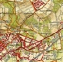
With this article you can see topographic maps and orthophotos from Belgium digitally.
You have the ability to use different map layers, allows you to select the card detailing.
CLIL French you can put the website in French. So your concern …
Website (7)Teacher -
Provinces and Capitals: Review Exercise

In this quiz you can repeat the subject matter about the provinces and their capitals.
Translated by
Interactive exercise (15)Teacher -
Coordinates search

When traveling, I have a photo taken at a particular point. There was a sign with the corresponding coordinates. The question is: where the master is. Exercise in latitude and longitude location.
(Private pictures)
Translated by
Downloadable resource (12)School/education -
Science on stage: STEM learning resources

European network of STEM teachers who, among other things, provide downloadable STEM publications.
A selection of the topics:
- doppler effect
- photosynthesis;
- genetic material;
- climate change;
- light leather;
- natural selection;
- moon phases; …
Translated by
Website (9)Teacher -
Topo Base: Geographic situate

This resource contains geographically tutorials: aanwijsspelletjes, puzzles and quizzes.
Allows you practice the location of include rivers, seas, oceans, mountains, cities, countries and continents. In
You can choose from the Netherlands, Europe …
Translated by
Website (9) -
What is an eclipse?

What is a solar eclipse or eclipse? How does that work? In this instructive video you will all know that.
Translated by
Video (6)Teacher, Other -
Scientix: European network for science education

Scientix is an engaged community for scientific education in Europe. They aim to promote collaboration between STEM educators, education researchers and policy makers, with the aim of inspiring students to pursue careers in science, technology, …
Translated by
Website (3)
Yummmm… cookies!
We don't like being tracked either. That's why we're concerned about your privacy.
Necessary cookies: for the proper operation of the website.
Functional cookies: for your convenience. recommended
Social media cookies: to view embedded media such as videos from YouTube, Facebook … recommended
Statistical cookies: for anonymous data collection to enhance user experience.